Day Hiking the Ozarks: Exploring a Geological Wonder

Entry posted by Susan Dragoo in Trips ·
6,763 views
The Ozarks of northwest Arkansas and southern Missouri are full of magical places, and thanks to the rest of the world’s inattention to this glorious natural area, solitude can often be easily found. Eye-catching geology abounds as a consequence of erosion of the high plateau that created the peaks and hollows characteristic of the area.
Clear rivers and streams lace through limestone bluffs, interesting rock formations, over natural bridges and over waterfalls, making the Ozarks an outdoor paradise for nature lovers. Whether it's a short hike or a more strenuous adventure you're after, the Ozarks luckily have many trails to offer for those looking to hike and explore the area.

There are so many spots with stunning scenery in and around the Ozark Plateau that the best thing to do is base your adventure in one locale and explore for a few days. We recently visited the area near Jasper, a very small town on the Buffalo National River. There, we stayed at the Cliff House, a hotel and restaurant overlooking the “Arkansas Grand Canyon,” a wide canyon carved by the Buffalo, and took in three short, easy (all with relatively minimal elevation gain due to their short length), and very scenic day hikes.
Alum Cove
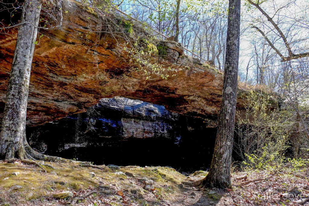
Natural bridges are surprisingly common in the Ozarks and one of the largest is at Alum Cove Natural Bridge Geological Area in the Ozark Natural Forest. The arch is 130 feet long and 20 feet wide, all that remains of what was once a quartz sandstone cave. Parking is near a sizable picnic area with tables and a restroom, a convenient stop before hiking down the switchbacks into the hollow. It’s only about 4 tenths of a mile to the arch but the entire 1.1-mile nature trail is worth the time to hike it. While it’s interesting walking atop the arch, the view from below is much more intriguing. The trail continues down the hill from the base of the arch and follows a bluffline with a shallow cave, then loops back up to the trailhead.
Directions
From Jasper, take State Highway 7 south for 15 miles. Turn west on State Highway 16 and go 1 mile. Turn northwest on Newton County Road 28 and go 3 miles.
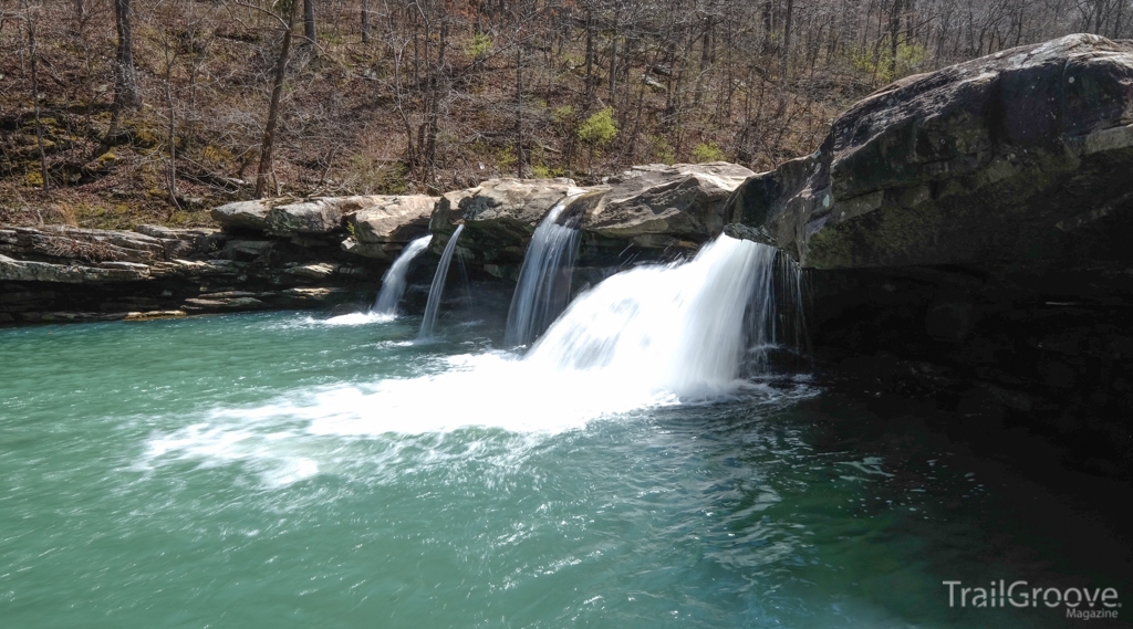
Kings River Falls
The highlight of this easy, level two-mile round trip day hike is a waterfall flanked by broad stone slabs perfect for picnicking and sunbathing. Kings River Falls is a popular swimming hole in the summer, but visit in cooler weather and you may have it all to yourself. Most of the trail passes along the Kings River, a clear mountain stream on your right, and on your left a hay field defined by an old rock wall. A grist mill once stood at the big falls — look closely for marks carved into the stone.
Directions
From the community of Boston on State Highway 16 (between Fallsville and St. Paul), go north on County Road 3175 for 2.1 miles; bear right as the road forks onto County Road 3415. Stay on this road for 2.3 miles until you come to a "T" intersection with County Road 3500. Turn left, and go across the creek and park at the natural area sign.
Glory Hole Falls Trail
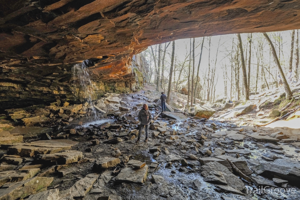
I’d wanted to see this place in the Ozark National Forest for years and it was definitely the highlight of the trip. The 1.9-mile round trip trail is a more moderate hike that follows an old roadbed that drops down the hill to a place where Dismal Creek falls through a large opening through the roof of a bluff. The trail winds its way from the trailhead to the top of the bluffline where you can see the opening from the top. On the right there is a way to continue to the bottom. It is steep and slick in places as you enter a moist glade area. Once there, you can walk beneath the overhang and immerse yourself in the beauty of the waterfall, especially dramatic after a rain. Use caution, a hiker was critically injured here in 2015 when he fell 25 to 30 feet off a ledge to the rocks below.
Directions
From Edwards Junction (the intersection of State Highways 16 and 21) travel west on 16/21 for 2.3 miles, going 0.7 miles past the Cassville Baptist Church. There is a parking area with room for several vehicles on the south side of the road, opposite a house up on a hill. Park along the highway and hike along the 4WD road, turning right at the bulletin board.
Additional Resources for Hiking in the Ozarks
Two books with more information on hiking in the Ozarks can be found in Arkansas Hiking Trails and Arkansas Waterfalls, both by Tim Ernst. The Ozark National Scenic Riverways, managed by the National Park Service, offers hiking opportunities in the Missouri Ozarks and access to the Current and Jacks Fork River. About 30 minutes from Scenic Riverways, Rocky Creek Conservation Area offers additional trails and short hikes.
For longer backpacking adventures, you can find more information about the Ozark Trail in Missouri at the Ozark Trail Association website, and one could tackle the Ozark Highlands Trail.
-
 2
2

1 Comment
Recommended Comments
Create an account or sign in to comment
You need to be a member in order to leave a comment
Create an account
Sign up for a new account in our community. It's easy!
Register a new accountSign in
Already have an account? Sign in here.
Sign In Now