The High Point of Texas: Hiking Guadalupe Peak
Entry posted by Karen Garmire in Trips ·
26,609 views
A spur of the moment side trip landed us in the Guadalupe Mountains National Park with easy access to the tallest point in Texas. Guadalupe Peak looms over the surrounding desert flatlands at a respectable 8,751 feet, accessible only after paying the price of a grueling 8.4 mile round-trip, 3000-foot elevation gain trail. This is truly a spectacular not-to-be-missed hike that comes with bragging rights for ascending the highest peak in Texas.

Located in Guadalupe Mountains National Park, Guadalupe Peak offers a challenging hike with expansive, rewarding views.
Hiking to the Summit of Guadalupe Peak
There is nothing predictable about this trail; we hiked it in early April during unseasonably cool weather and were surprised with a wide range of weather conditions. Our hike started out sunny, with warm temperatures and calm winds that changed to light wind, cooler temperatures and even a few snow flurries as we ascended toward the peak. That being the said, it’s not unusual to start out in sweltering heat and arrive at the top needing some serious cold weather gear.
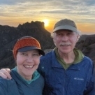
We were lucky to have a break in the wind and clouds when we arrived at the top that allowed us to take time to enjoy the view of Texas and southern New Mexico to the north. This is a shoulder season hike, best hiked during the cooler months of the year. Peak seasons in the park are March through May and September through December when average high temperatures are less than 80 degrees.

The trail is well maintained and a reasonable (but constant) grade. The steepest portion is in the first couple of miles. A few sheer drop offs are not for the faint of heart. However, the trail is wide with passing room along virtually the entire trail and the cliff side paths make for impressive photos. Many families make this hike with children. Sturdy hiking shoes or boots will make the mostly rock tread easier on your feet but are not required. We opted to use trekking poles, but most hikers went up fine without them (we like to use trekking poles so we can take in the scenery with less risk of stumbling).

As you make your way up from the trailhead at roughly 5750’ to 8751’ elevation at the top you’ll notice the stark changes in your surroundings from the high desert to high elevation pinyon tree forests. The progression offers a fascinating lesson on the adaptability of flora and fauna to these unique ecosystems. We didn’t see too much in the way of wildlife on the hike, except for a few lizards on the rocks and vultures and hawks flying overhead. An earlier start would likely provide a better chance to see some of the local animals (gray fox, skunks, porcupine, mule deer, snakes, etc.).

Those that make the trek are rewarded with a 360-degree view for miles on end with mountain peaks rising from the surrounding Chihuahuan Desert. Guadalupe Mountains National Park is home to eight of the highest peaks in Texas including the impressive sheer limestone bluff, El Capitan, not to be confused with the similarly named and equally impressive rock formation in Yosemite National Park.
There is no trail to the top of El Capitan, but the best view in the park is from atop Guadalupe Peak. Off in the distance, and barely visible are the 2,000-acre gypsum sand dunes on the west side of the park. The monument on Guadalupe Peak is a quirky pyramid that was put on the peak before it became a National Park and commemorates the transcontinental overland and air mail carriers. If you plan your trip during the spring, you’re likely to see spectacular blooms that may even include the rare Guadalupe Mountain violet!

The hike starts out in the high desert and passes through high elevation pine forests. If you have an extra day, and don't mind carrying a backpack and extra water, you could camp overnight at the backcountry campsite one mile from the summit and enjoy star gazing before summiting the next morning and possibly catching sunrise from the peak. Guadalupe Mountains is sometimes described as the least visited national park, but it’s one not to be missed in our book.
Need to Know
Information
The National Park Service advises carrying one gallon of water per day and turning back when half your water is gone. There are no water sources on this trail.
No-fee backcountry wilderness permits are available at the visitor’s center up to one day in advance. The campground with five tent sites is one mile below the peak. All toilet paper and solid waste is required to be removed in a commercial toilet bag (Wag-Bag or the Restop 2, etc). One bag per person, per day is required for backpackers and you may be asked to show proof you have the required bags before obtaining your permit.
Guadalupe Mountains is in the Mountain time zone although your smart phones and other devices may try to convince you otherwise since the nearest towers transmit from the Central time zone. The sparsely populated area makes Guadalupe an ideal location for dark sky viewing. There is a fee to enter the park, however the wilderness permit is free.
Getting There
Guadalupe Mountains National Park is located in west Texas about 2 hours east of El Paso. The trailhead parking lot holds only a few cars and fills up quickly even on weekdays. There is additional parking at the visitor center and the well maintained trail to the trailhead adds a bonus mile to your hike. A quick stop at the Pine Springs Visitor Center is highly recommended for the latest forecast and sage advice. If you are planning an overnight excursion you must get a backcountry permit here.
Pine Springs Campground is located at the trailhead with 13 RV sites and 20 tent sites. These must be reserved in advance and the campground is often full. Chosa Primitive Camping Area, a much larger campground managed by the BLM is 29 miles to the northeast on the road to Carlsbad Caverns National Park. It is suitable for both tents and RVs. Chosa is a dispersed, dry camping free area with no facilities.
Best Time to Go
The best time to hike would be spring and fall to avoid possible extreme summer heat. Start early in the day.
Maps & Books
The park is covered in the National Geographic Trails Illustrated Guadalupe Mountains National Park map. In addition, the Delorme Texas Atlas can help with getting to and from this and other destinations in the state. In regards to guidebooks, see Hiking Carlsbad Caverns & Guadalupe Mountains National Parks as well as Best Easy Day Hikes Carlsbad Caverns and Guadalupe Mountains National Parks.
-
 1
1
-
 1
1


1 Comment
Recommended Comments
Create an account or sign in to comment
You need to be a member in order to leave a comment
Create an account
Sign up for a new account in our community. It's easy!
Register a new accountSign in
Already have an account? Sign in here.
Sign In Now