Along New Mexico's Cabezon Road
Entry posted by Steve Ancik in Trips ·
5,635 views
I have been exploring interesting and scenic areas in New Mexico for several years. Often these visits have been at the beginning or end of longer trips to places farther west, so the visits are often just a day or so – much less time than the area deserves. I am especially intrigued by the so-called “badlands” of the northwest part of the state. These badland areas include several wilderness areas, including the better-known Bisti/De-Na-Zin Wilderness. I first drove down Cabezon Road to ride my mountain bike at a trail system along the road, but soon found that there are several more things to do and see in the area, both before and beyond the mountain bike trails.

“Cabezon'', by the way, means “big head” or ''stubborn”, and is so-named because of Cabezon Peak, which stubbornly stands high above the plains to the northwest. The places that I have explored along Cabezon Road are, at least in part, the Tierra Amarilla Anticline and Ojito Wilderness, and of course the scenery and geology of the bike trail area itself.
Tierra Amarilla Anticline a.k.a. San Ysidro Anticline
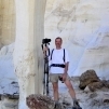
An anticline is where the earth’s crust has been folded into an upward pointing curve, like an upside down “U”. Along the east side of the Tierra Amarilla Anticline, the rocks are tilted up to the west, and along the west side, tilted up to the east. The entire center of the anticline has been removed by erosion, as seen from the White Ridge Bike Trails. As you approach the anticline from the east, keep your eyes peeled for a “soft serve ice cream cone” formation on the right. It is somewhat hidden by the hills and ridges along the road until it is at your two o'clock position a couple hundred yards away. This hoodoo is sitting next to a “sinking ship” rock that is quite photogenic. On my last visit, I was climbing around the rocks and there was a pair of ravens watching me very closely and even hovering overhead for a while. I assumed that they had a nest nearby, so I quietly moved on to another area.

The rocks of these formations range in color from tan to orange with areas of yellow, brown, red, and even some that are nearly black. Since the rocks are tilted at a nearly 30 degree angle, exploring the area consists of climbing up and down around the steep slopes. The center of the anticline has been removed by erosion. The bike trails follow the ridge on the left side then wrap around the north end, and then head back south and follow the ridge. I haven’t yet been down in the center of the anticline, but it sure looks interesting. Maybe next visit.
White Ridge Bike Trails
These trails are primarily used by mountain bikers, but hikers are welcome. I’ve ridden there several times and if hiking, would stick to the eastern side of the trail system. There, the rocks and scenery are more interesting and varied. The eastern part of the anticline is exposed here, as well as several old geysers and travertine (a type of limestone deposited by mineral springs) deposits. There are a couple of places where there are open sinkhole-type features with water in the bottom–these are old geysers or geothermal springs. The water from these is high in minerals and has resulted in a series of terraced mineral deposits. The rock of these deposits is called travertine, and, when walked on, sounds hollow in places. To the east of the main mountain bike loop the anticline’s rocks are tilted up to the west, and this area has several interesting places to explore.
The Ojito Wilderness
This is a 11,823 acre wilderness area administered by the U.S. Bureau of Land Management. It was established in 2005. It is open to primitive camping, hiking, and horseback riding.
One of the largest dinosaur skeletons ever discovered, the Seismosaurus, was found here. The area is a dry environment of multi-colored sandstone with multi-level terraces, box canyons, and arroyos. Small numbers of piñon pine and juniper can be found in the area, as well as a stand of ponderosa pine – the lowest elevation stand in New Mexico.
Starting from the Hoodoo trailhead, head north for just over a mile along an obvious trail. Along the way there is an interesting outcrop of bright yellow sandstone with interspersed layers of pink and red sandstone. Continuing on the trail, you eventually reach an area with several 10 to 20-foot tall hoodoos and a few large ponderosa pines. I have camped here on two different occasions. Once you set up camp, the trail continues northward for at least another mile before turning west around the northern end of Bernalillito Mesa, which stands a couple hundred feet high to the west of the trail for the entirety of the hike. The views to the north are beautiful, with most of the wilderness area visible and inviting one to explore more. From my short hikes in the area, it seems that there are ample opportunities for off-trail exploration. I have not hiked the Seismosaurus Trail yet, but intend to on my next visit. For further exploration, Cabezon Peak is apparently accessible by following a series of roads for about 20 more miles to the west and north from the Hoodoo Trail parking area.

Amazing rock formations near Cabezon
Need to Know
Information
Permits are not required for any of these areas.
Getting There
From the intersection of I-25 and US 550 at Bernalillo, go northwest on 550 for about 25 miles, then left (west) on Cabezon Road. A brown sign points to White Ridge Mountain Bike Trails. Along Cabezon Road, after a couple of miles there are several places to pull off to explore the eastern side of the anticline before arriving at the mountain bike parking lot. The parking lot for the White Ridge Trails is on the right 4.4 miles from the highway. Continuing five miles further takes you to the first parking area for the Ojito Wilderness. This is the Seismosaurus Trail, and one mile further is parking for Hoodoo Trail. Visible in the distance to the northwest is Cabezon Peak, part of an old volcano. It is another 19 miles on Cabezon Road.
Best Time to Go
The elevation of these places is around 5700 to 6000 feet above sea level. March thru May have nice temperatures, but April is the windiest month. September and October also have comfortable temperatures, but August thru October are the wettest months. There will occasionally be snow in the winter, and summer months can have daytime highs in the 90s.
Books and Maps
60 Hikes within 60 Miles: Albuquerque (2nd Edition, pages 206 (White Mesa) and 211 (Ojito Wilderness)) by Stephen Ausherman. Delorme New Mexico Atlas and Gazetteer and / or BenchMark Maps, New Mexico.
-
 1
1

1 Comment
Recommended Comments
Create an account or sign in to comment
You need to be a member in order to leave a comment
Create an account
Sign up for a new account in our community. It's easy!
Register a new accountSign in
Already have an account? Sign in here.
Sign In Now