A New Mexican Oddity: Hiking to the Paliza Goblin Colony
Entry posted by Steve Ancik in Trips ·
12,700 views
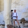
Even though this sounds like somewhere from J.R.R. Tolkien’s Middle Earth, it is indeed a place here on our Earth, in northern New Mexico. I had already planned a trip in May 2021 to see some New Mexican scenery, and this was right along the route, so I added it to the itinerary, and boy am I glad that I did! Leaving the somewhat boring highway, my hiking buddy Rod and I headed up into the Jemez Mountains where the colony is located. Climbing up higher into the hills, the scenery changed from dry semi-desert to ponderosa pines over about 10 miles. High on the cliffs along the road was a layer of odd-looking rock with numerous holes and caves – this turned out to be a layer of volcanic rock, and is the rock in which the Paliza Goblin Colony is found. The “goblins” are eroded volcanic columns or hoodoos with many holes, which, if looked at just right, can resemble ghoulish faces.

The Paliza Goblin Colony makes for an interesting hike with intriguing rock formations.
The Hike
We stopped along the drive at the Paliza Family Campground where we camped for the night. This is a first-come, first-served National Forest campground, and is really well taken care of and has very nice campsites, surrounded by towering ponderosa pines. Once we set up camp, we drove less than a half mile further up the road, left the car, and began the hike. It is a relatively short hike to the goblins, just around a mile and a half to the lower end of the colony. The hike begins along a now closed forest service road, which eventually narrows down to a singletrack trail. There is only a couple hundred feet of elevation gain to this point.

Arriving at the colony, we were captivated by the view of hundreds of rock columns. Scattered amongst the hoodoos are many ponderosa pines and some alligator junipers on a steep hillside to the left (west) of the trail. And by steep, I do mean steep! The hillside on which the hoodoos are located gains over 250 feet in under 0.2 miles to the top. Climbing straight up is not really an option, as the ground is soft with layers of loose sand and gravel. Zig-zagging up and around the goblins is the best bet, and gives plenty of opportunities for photographs and seeing views of the surrounding canyon. Since the extent of the colony is maybe only 250 by 250 feet, you can see it all in a short period of time, provided your legs are up to the steep climb. We spent a couple of hours there, then decided to do our return hike on Forest Road 10, which passes near the upper end of the colony. Our total round-trip for this hike was about 4.5 miles.

After spending the night at the campground, we got up to a beautiful sunny morning. This was a huge contrast to the previous day when it was heavily clouded and occasionally sprinkling. We decided to drive up FR 10 to visit from the top down. Definitely a good decision! This gave us a different perspective on the goblin colony, and gave me more and better photographs – this was an excellent spot to visit.
Need to Know
Information
No permits are required to hike in this area. The climb up through the hoodoos is steep, so trekking poles will help with the climb. The site is at around 7,400 feet elevation, so take your time if not accustomed to higher elevations. The Paliza Goblin Colony is a remnant of a volcano which erupted 1.25 million years ago.
Getting There
From Bernalillo NM, take US 550 north to San Ysidro, then turn right onto State Route 4 toward Jemez Pueblo. Just past Jemez Pueblo, turn right onto SR 290. Continue for about nine miles to Paliza Family Campground on the right. If you are going directly to the trailhead, turn left on Forest Road 10 (just before the camp) and continue about 0.4 miles to a small parking area where FR 290 joins FR 10. Park here and hike to the north on the old road bed. It’s just over 1.5 miles to the goblins (stay left at intersections). Alternatively, if FR 10 is open past the parking area, you can drive to the top of the goblins and park on the side of the road and climb over the ridge on the east side to get to the top of the goblin area – but that is cheating, and I don’t recommend cheating!
Best Time to Go
Spring, summer, and fall. The goblin colony is at around 7,400 feet elevation, so it will be cooler than the surrounding desert.
Maps and Books
USGS maps Ponderosa and Bear Springs Peak cover the area of the Paliza Goblin Colony and surrounding canyons. A New Mexico Atlas can be useful for getting to and from trailheads, and 50 Hikes in Northern New Mexico details other hiking opportunities in the Northern New Mexico area.
-
 1
1

0 Comments
Recommended Comments
There are no comments to display.
Create an account or sign in to comment
You need to be a member in order to leave a comment
Create an account
Sign up for a new account in our community. It's easy!
Register a new accountSign in
Already have an account? Sign in here.
Sign In Now