Two Wheelers: Hiking Wheeler Geologic Area & Wheeler Peak
Entry posted by Steve Ancik in Trips ·
693 views
Since my sister Melissa retired, we have taken several hiking, backpacking, and photography trips together. This time, we headed to Colorado and New Mexico for another adventure. Melissa has wanted to hike to Wheeler Peak for years. I’ve wanted to see the Wheeler Geologic Area for years. So, we combined the two desires into one awesome trip – The Tale of Two Wheelers.
Hiking & Exploring Wheeler Geologic Area
We started off early on the morning of July 5th and headed west across Oklahoma, experiencing a spectacular sunrise out of the rear-view mirrors on the way. We camped our first night in the Spanish Peaks area of southern Colorado, then the next morning, we headed to Hanson’s Mill near Creede. The road to Hanson’s Mill (apparently the site of an old lumber mill no longer in existence) is fairly well graded and accessible by most vehicles. The area at the end of this road has several campsites, but it is a fairly open sun-drenched area (due to dead trees having been cut and removed), with only a few scattered standing trees.

The only facilities here are a vault-type toilet, a few picnic tables and fire rings, but no water or refuse receptacles. Beyond Hanson’s Mill, the route (Forest Road #600) quickly deteriorates into a one-lane, rough, rocky four-wheel drive, high clearance road for 14 miles. It took us about 2 ½ hours (with a few photo stops) to arrive at the end of the road at the trailhead for Wheeler Geologic Area. There is an 8-mile long hiking trail (Trail #790) that begins at Hanson’s Mill, which would be the alternate way to the geologic area if you don’t have a car capable of the rough 14 mile drive.
The Engelmann spruce forest in this area has been devastated by spruce broom rust (caused by a fungus) and spruce beetle epidemic which has killed vast stands of the spruce. The old forest was already stressed by disease and weakened by extended drought and a warmer climate when the beetles were able to really start their attack. Today, though the epidemic has slowed – killing almost all the trees susceptible to the outbreak – it continues in isolated pockets.
Younger trees seem to be healthy, as confirmed by a college-aged forester along the road, to whom we spoke. She described the forest and how the beetles kill the trees, how they are a natural part of the cycle, how climate change has contributed, etc. The forest service has been putting pheromone packets on some trees which signal to the beetles that “this tree is already full” to prevent the beetles from infesting the healthy trees. Eventually, this forest may look better as the older, still-standing dead trees fall and the younger ones grow up, but for now, it is surely sad to see.

According to the descriptive signs at the trailhead, 30 to 40 million years ago, lava flows that were nearly 4,000 feet thick covered an area of 9,000 square miles. Then about 29 million years ago, a massive pyroclastic (ash, dust, volcanic rock, and pebbles) eruption engulfed the area, producing large quantities of volcanic ash, also known as tuff. For nearly three million years, thirteen volcanoes covered the area with up to 3,000 feet of ash. Subsequent erosion has exposed this ash, resulting in the spectacular scenery of the area.

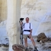
At the end of the rough road, there are several dispersed camping sites in the fields and woods at the parking and turn around point (in this area there seemed to be fewer dead trees), and we chose a spot and set up camp. We then loaded up our day packs and began our hike, which begins at an elevation of 10,840 feet. We hiked the Wheeler Loop counterclockwise, with a side hike out to Halfmoon Pass, then back down to the Wheeler Loop and on around the loop. Coming from 1,200 feet with very little time to acclimate to the elevation, we found it to be a very strenuous hike, especially me. At the top of the pass, there was a small patch of snow, so we took photos of each other throwing snowballs.

As we continued, we finally arrived at the reason we were there in the first place – the bizarre eroded rocks of volcanic ash. The actual area isn’t huge, but it is quite spectacular. The light-colored volcanic tuff has been eroded into spires, steep cliffs, towers, castle-like shapes, and, if you use your imagination, goblins and gnomes. We almost got there too late – the area faces west, but is partly blocked by some higher cliffs to the west. When we arrived, the sun was getting low and parts of the ash layers were already in shadow. We still got some good photos, but if I were to do it again, I would take the hike clockwise and see the formations first. Our hike here was 6 ½ miles long with around 1,800 feet of climbing.
Over the next few days we visited the town of Creede, hiked to several waterfalls in the area, drove on some crazy 4wd roads, went to Crested Butte to see the wildflowers (Wildflower Capital of Colorado), and then drove south to Red River, New Mexico.
Hiking Wheeler Peak
For our final hiking day of the trip, we drove to the Taos Ski Area where the trailhead for our Wheeler Peak hike starts. The trailhead is at an elevation of 10,200 feet, and starts off as a fairly wide, well-used trail. It slowly climbs over the first couple of miles to a turnoff to Williams Lake. The lake, at an elevation of 11,040 feet, is a short distance away. We stopped just before the lake for a snack and to take some photos.
There were quite a few tents on both sides of the lake and a lot of people on the trail to and from. Having had a week to acclimate to the elevation, this first part was not nearly as difficult as our initial hike at Wheeler Geologic Area. It naturally got more difficult on the hike up to the peak. From the lake, we returned to the intersection and headed up the trail to Wheeler Peak. The trail starts off in dense woods where we heard and saw numerous birds. As you climb higher, the trail finally gets above the treeline, and views open up.

From the trail, the destination peak is visible, as well as some of the switchbacks yet to be climbed, the Taos ski runs, and several other nearby peaks. And below, in the distance, we spotted Williams Lake several times – those tents looked very tiny from this distance and elevation! After leaving the woods, the switchbacks happen more often and the trail gets steeper. In several spots the trail crosses large scree fields (broken chunks of rock of various sizes that have tumbled from above and settled on the slope), which are places we had to be extra careful so we didn’t twist an ankle or fall. The last quarter mile, just before you arrive on a ridgeline, is the steepest with dust, sand, and small gravel on the trail bed.
Once on the ridge, it’s a short (and easier) hike to the actual peak. Wheeler Peak stands at an elevation of 13,161 feet. There is a plaque and a register to sign there. When we arrived, there were a dozen or so people on and around the peak, but most were in a group and soon left, leaving us with just a few others. We took the “mandatory peak photos” (thanks random citizen!), had a quick lunch (thunderstorms were brewing in the distance), and then headed down. Going down uses muscles in a whole different way – knees bent, tiny steps so we didn’t slip, and constant braking.

We had put on jackets up top, but soon stripped them off because of the exertion. We spotted a couple of raptors flying and doing high-speed dives at one point (we heard the whoosh of the air past the feathers of one). The rest of the hike down was uneventful. We arrived back at the car, quite tired but satisfied by this epic hike. The hike was a total of 9.4 miles round trip with 3,094 feet climbed and descended. It took us 6 ½ hours to complete the hike.

The next day, our drive home was long but uneventful. This was a great trip, and we saw so much! Waterfalls, mountains, rivers, mountain lakes, rough roads, and enough scenery to make us quite content (for a while). On top of that, we accomplished two long-term wish list items and took hundreds of photos. Let’s go do another!
Need to Know
Information
There are no fees or permits required for either of these hikes. Driving to Wheeler Geologic Are requires a high clearance vehicle, preferably with four wheel drive (although we did see a Subaru Crosstrek along the way (I wouldn’t recommend it). Camping at the end of Forest Road 600 is limited to first come, first serve. Parking for Wheeler Peak is at the Taos Ski Valley. There are a couple of other longer hikes to Wheeler Peak, with different parking locations.
Getting There
Wheeler Geologic Area is near Creede, Colorado. From Creede, travel southeast on Colorado Highway 149 for 7.3 miles, to the intersection of Colorado Highway 149 and Forest Road #600 (Pool Table Road), then approximately 9.5 miles northwest on Pool Table Road #600 to Hanson’s Mill. From here, a high-clearance 4wd vehicle is needed to continue the 14 miles to the Wheeler Geologic Area Trailhead.
Wheeler Peak is north of Taos, New Mexico. From Taos, travel approximately 4 miles north on US HWY 64 from Taos to the junction of NM State HWY 150, then east on HWY 150 to Taos Ski Valley. Continue through the Taos Ski Valley parking lot, veering left up Twining Road. Twining Road is approximately 2 miles long and contains several switchbacks. It will be fine for most vehicles in the summer and fall (4x4 in winter). Follow signs for the Williams Lake Trailhead and the Bavarian Lodge and Restaurant. Park at the large parking lot on the right as the road levels off (this parking area is before the Bavarian).
Best Time to Go
Both of these places are late spring to summer to early fall destinations, typically best from May or June through October. Both can experience thunderstorms (particularly in summer) with lightning, usually in the afternoon.
Maps
Trails Illustrated 139 La Garita Cochetopa Hills as well as Trails Illustrated 730 Taos Wheeler Peak. For getting to and from trailheads and exploring other hiking opportunities in the region see the Delorme Colorado Atlas & Gazetteer as well as a New Mexico Atlas.
Editor's Note: This article by contributor Steve Ancik originally appeared in Issue 58 of TrailGroove Magazine. You can read the original article here for additional photos and content.
0 Comments
Recommended Comments
There are no comments to display.
Create an account or sign in to comment
You need to be a member in order to leave a comment
Create an account
Sign up for a new account in our community. It's easy!
Register a new accountSign in
Already have an account? Sign in here.
Sign In Now