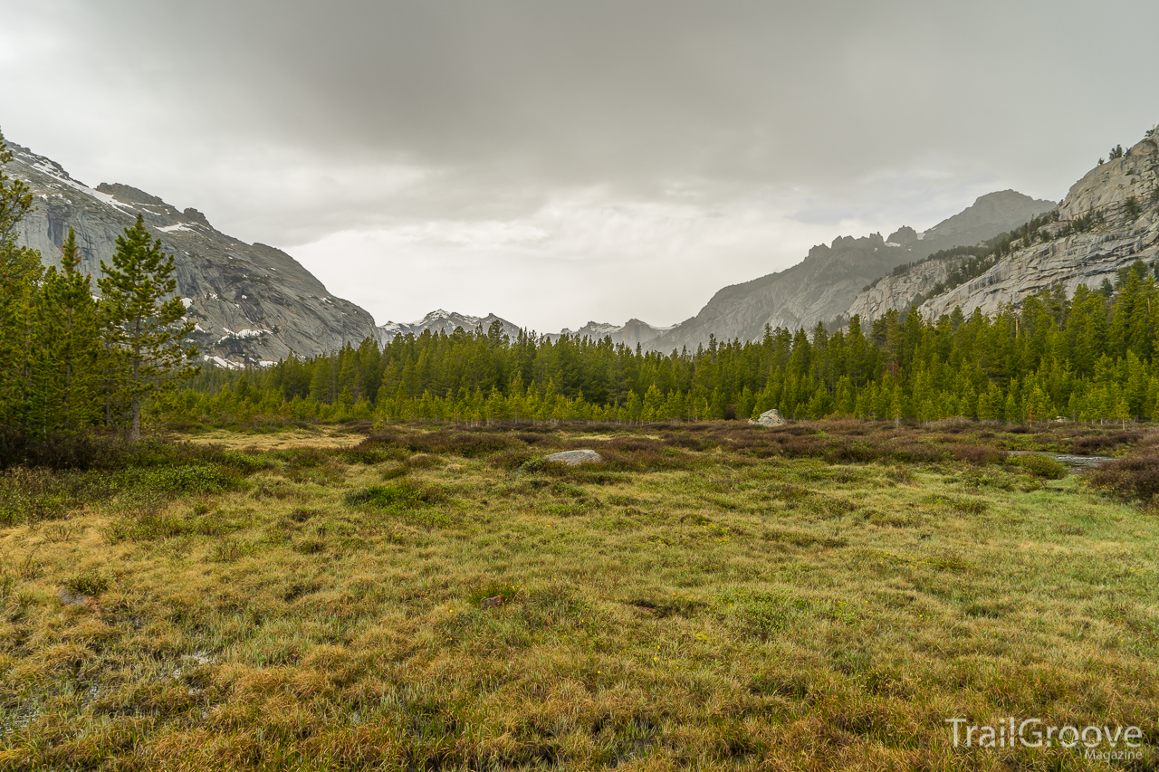
After a drive into the night and an examination of the small walk-in Devils Lake Campground by headlamp, I found an available campsite – close enough to the trailhead that it was safe to say the first part of my journey (getting there) was complete. It was quiet, but there were several others camped nearby. The peaks that dominated the wilderness trip ahead of me were obscured by the darkness of the night. I was excited for the backpacking trip ahead of me, a nearly 60 mile variation of one of O
Memories can be painful and happy. As I drove through the darkness past the national park boundary near Moran Junction, I reflected a bit on my last trip to the Tetons. In June 2001, my Boy Scout troop took a trip to Grand Teton and Yellowstone, and during that trip we backpacked one night up Granite Canyon. I know it was my first backpacking trip outside of Colorado and maybe my second or third backpacking trip ever. Two distinct memories pop out from that trip. I remember how beautiful the mou
Most backpacking trips enter a figurative “Paradise” at some point or another. It could be an exquisite sunset, a perfect campsite, or time spent mesmerized by a waterfall. My trip along the Selway River Trail with my stalwart backpacking companion Justin had the amusing distinction of actually beginning at a Paradise. The Paradise boat launch and trailhead in the Bitterroot National Forest in a remote corner of Idaho, to be exact.
From here we would follow the Selway River downstream
As a backpacker, I’ve found few things more enjoyable than hiking over a nameless and trail-less mountain pass to beautiful subalpine lakes with trout swimming in their frigid waters. In the mountain ranges of Montana, this isn’t too difficult a feat to accomplish, at least logistically. However, the physical challenge of gaining nearly a thousand vertical feet in well under a mile of horizontal travel is nothing to scoff at, regardless of your conditioning. With millions of acres of public land
Imagine a wilderness area of tundra ridge walks, a place where 13,000-foot peaks tower into the sky, where wildflowers dot the landscape, and bighorn sheep scramble over the terrain. A wilderness area that would seem to be the stuff that backpacker dreams are made of. Now picture this area tucked away in northern New Mexico. An area ignored by many backpackers. No major long distance hiking trail comes through these mountains. No glossy travelogues feature this wilderness area. This wilderness a
Distance mode. Proximity mode. Red light night vision mode. At 90 lumens, my new Black Diamond Spot headlamp is the newest addition to my backpacking kit in ages. For the second or third time on today’s maiden voyage hike, I unsheathe the Spot from my Gregory Z65’s brain pouch, cradle it in my fingers, and imagine how its endless wonderful qualities will make every trip better. The blood red bezel’s sharp lines attach to a diagonally-shaded retro headband conjuring the aura of Optimus Prime.
We shuffle off the bus and melt into a crowd of tourists, all headed for the perfectly framed view of the Maroon Bells surrounded by bright yellows and greens. Just a minute from the parking lot and we’re already sold on our three-day adventure. More commonly a four-day trip, the Four Pass Loop is one of the most popular – and most photographed – backpacking routes in the United States.
The 28-mile trek takes hikers over four mountain passes, ascends and descends over 7,800 feet, and
The Lost Coast Trail (LCT) in northern California may very well be the best beach hike in the United States. The name derives from the fact that it is the only part of the California coast that is not paralleled by a highway. I’m sure the romantic ring of that name only adds to its considerable popularity. It sounds like something from a teenage adventure novel. “The Hardy Boys and the Pirates of the Lost Coast”
There is a northern section and a southern section. The southern stretch is muc
Like most Americans who were raised in the East and born after the mid 1970s or so, volcanoes are something I associate with middle school science classes and dramatic pictures of Mount Saint Helens and its 1980 eruption. Even after I became enthralled with backpacking and natural landscapes after frequent trips to the sandstone wonderlands of the Cumberland Plateau and the forested slopes of the ancient Appalachian Mountains, hiking around a volcano seemed like a ludicrously exotic experience.
I awoke in the comfort of the back of my vehicle as the Pacific Ocean’s peaceful waves gently moved across the nearby beach. I quickly drove away and soon found myself driving on a remote forest road. Fortunately I had checked road conditions and discovered that I needed to detour to avoid a landslide. The road was bumpy and had deep cracks. My vehicle has all-wheel drive, but not high clearance. With careful maneuvering I arrived at the Chetco Divide/Vulcan Peak Trailhead and the edge of Oregon
5am – July 4th 2013 – “What am I doing?” pops into my head before getting a few hours of sleep. The previous night entailed 8 hours of driving to shuttle my car to the end of Forest Road 43 in the middle of nowhere. After leaving it in darkness on the far eastern slope of the Uinta Mountain Range, we switched cars and drove another five hours to reach our destination. My GPS showed that I was over 55 miles away from where we had left the car, but I knew the trek to get there would be closer to 8
A few drops of rain and an empty parking lot greeted us at the trailhead where we paused for a few moments of contemplation. I’m not sure if I was more nervous about the responsibility of backpacking with a dog for the first time or if my girlfriend was more nervous about Lolo and I spending the weekend in grizzly country without her there to supervise. Lolo just seemed excited and happy, which were contagious emotions and aside from occasional hunger and tiredness proved to be the definitive fe
With age comes wisdom, or so goes the old adage. But, as any observer of the world can plainly see, that’s not always true. With age certainly comes knowledge, but whether that knowledge is converted to the making of wise decisions is, so to speak, a crap shoot.
Hiking in the Grand Canyon offers an excellent example. First of all, it’s challenging business. For us to successfully descend to the bottom and return to the rim in good health, we would have to gain adequate knowledge but we'd al
With names like Gnome Tarn, Dragontail Peaks, and Aasgard Pass, you’d think I’d stumbled into a land of Norse Sagas. But instead I walked through a land of water and granite surrounded by the fall color of subalpine larch. The Enchantments are a small section of the Alpine Lakes Wilderness in northern Washington’s Cascade Range. This is a land of high valleys and beautiful aqua-marine lakes, all lying under the ever-present view of Prusik Peak.
While an Enchantments hike can offer rew
I wince with every step as I cross the river. Bare feet had seemed like a good idea. But now, after too many crossings to count, my soles feel the pain. I grip my trekking poles for stability against the current and tread cautiously on the slick stones, picking my way to the other side.
The river glitters in the late afternoon sun. Jessica and Shay are already on the opposite bank, searching for yellow blazes. Before attempting this crossing, we had bushwhacked away from the last vestiges o
We arrive on the shore of the Buffalo River in northwest Arkansas on a chilly morning in early November 2022, wearing old tennis shoes we have repurposed as water shoes, to begin forty-two miles of hiking on the Buffalo River Trail (BRT). In spite of the cold, we will start this hike with wet feet. But warm socks and dry hiking boots await us once we wade up to our knees across the shallow ford at Woolum and cross the more challenging Richland Creek, a narrower and deeper stream that empties int
I stood, breathless and exhausted, on the top of the divide, looking down at the pristine and untrailed cirque that lay ahead. My route bared before me, for a moment continuing on across the three passes that lay ahead seemed achievable. Then my eyes lifted to the glaciated massif of 7,600-foot Mount Mystery on the opposite wall of the basin, and my shaking legs sent an unmistakable message: I would make it no further.
Olympic National Park offers hikers rugged terrain and stunning vi
The Pictured Rocks Lakeshore Trail is one of the best coastal hikes in the United States. This 42 mile trail has been called one of the crown jewels of America’s longest National Scenic Trail, the North Country Trail – a trail that runs from North Dakota and will soon terminate in Vermont. The Lakeshore Trail includes a variety of coastal features including sand dunes, a remote wilderness beach, and impressive cliffs high above Lake Superior. The trail is located in Pictured Rocks National Lakes
After the landscape itself, the memories made with companions, and the wildlife seen, the weather is usually one of the most memorable parts of a backpacking trip. Bluebird skies, sideways rain, scorching heat, unexpected inches of snow – these are often the things which come to mind when reminiscing on trips where weather was either a blessing or a curse. In much of the West, another weather phenomenon also has an outsized influence: smoke. Even if you’re hundreds of miles from an active wildfi
If there is such a thing as a backpacker’s paradise then look no further than the Kungsleden, Sweden’s Royal Trail above the Arctic Circle near the border of Norway. If you can hike just one section of the 240-mile long trail, start with the world-class hike between Nikkaluokta and Abisko. Imagine wide Arctic valleys, stunning northern lights, reindeer, and, if you go in September, incredible fall colors covering the landscape. The 80-mile hike from Nikkaluokta to Abisko can work for all skill l
Located approximately 15 miles off the Minnesotan and Canadian shores of Lake Superior, Michigan’s Isle Royale is the largest island in the world’s largest freshwater lake. This national park is a wilderness paradise with 99% of it officially designated as such. It includes scenic ridges, rugged coastal views, inland lakes, unique wildlife relationships, and an excellent network of trails. The island is 45 miles long and 9 miles wide. As the third largest island in the contiguous United States,
Waterfalls were perhaps the first natural landform that truly fascinated me. There was something about the phenomenon of water travelling so fast, so abruptly, and so seemingly endlessly that captured my attention in a profound way. I remember being amazed by them as a child during camping trips with my parents, with Cumberland Falls in Kentucky and Fall Creek Falls in Tennessee being the ones that made the biggest impression. As a young adult, I sought out waterfalls specifically during the bac
If you're in the Midwest, the Porcupine Mountains might be your #1 go to backpacking destination. Scenic views abound and old growth forests dominate the interior. Head to the north side of the park and you'll find yourself greeted with the pristine and beautiful waters of the world’s largest freshwater lake. For an excellent day hike, park at the Lake of the Clouds overlook and explore the Escarpment Trail (amazing views).
If a great view of the lake and a shoreline jaunt better suit
On this trip, I was able to return to Canyonlands National Park, but this time stayed on the opposite side of the river from the Maze to join up with Ted Ehrlich and Christy who drove in from Colorado to backpack through Salt Creek Canyon and the Needles.
The Needles offer a near endless array of unique rock formations to find and routes to explore.
Into the Needles
Our respective drives late on a Thursday night resulted in a noon-ish start from the Cathedral Butte trailhead
A few years ago and to follow up on a previous Utah hiking trip, Ted Ehrlich and I spent a few days backpacking in the Maze District of Canyonlands National Park. The Maze is frequently referred to as one of the most remote spots in the lower 48, and though I’m not sure how exactly it ranks on that scale, it did require some significant amounts of off-highway driving to reach.
The Maze is located in southeastern Utah, west of the confluence of the Colorado and Green Rivers and bordere